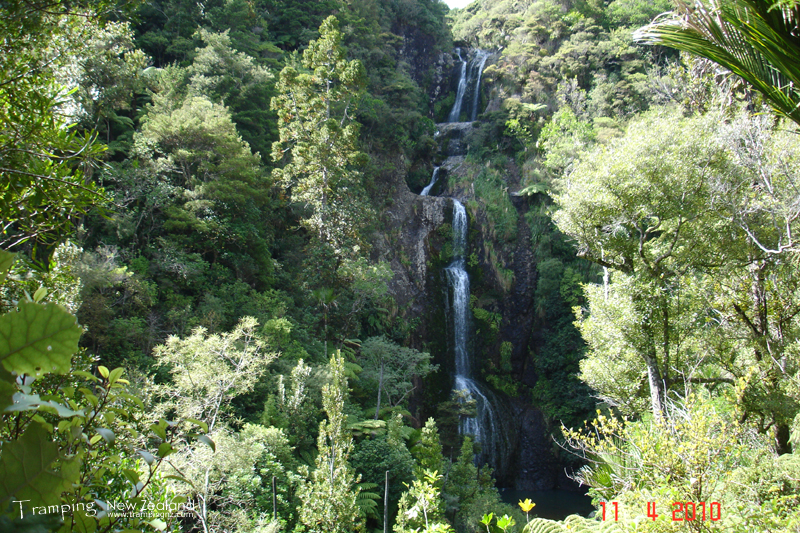
Kitekite Falls
Waitakere Ranges
11 April 2010
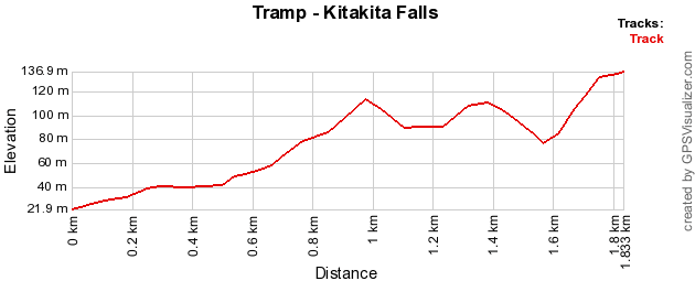
Kitekite Falls is an 80m waterfall which can be accessed by track takes 40 minutes in each direction. This is located in Piha within the Waitakere Ranges. I was joined by Bays Rover Crew for a walk.
| Day 1 | Waitakere Ranges, Piha Kitekite Falls Track via Kitekite Waterfall | 3.6km |
 (https://www.trampingnz.com/images/maps/kitakita_falls_2010.png)
Firstly you will need to travel to Glenesk Road, Piha. The track entrance is at the carpark at the road-end.
You will follow an easy well graded track, which follows Glen Esk Stream. This has small uphill/downhill as it follows up the valley to the falls. When you reach the lookout there is a huge bench and table so you can admire the view while having a snack.
 (https://www.trampingnz.com/images/02_auckland/kitakita_falls_large.jpg)
Kitakita Falls | Photo Credit: Chris Foster
From here you can drop down to the bottom of the falls, where you can have a cool refreshing swim.
You can also take Connect Track to the top of the Kitekite Falls, to see the view down the valley. This track also forms part of the recently established Hillary Trail through the Waitakere Ranges.
We returned back on the same track to the carpark.
View Larger Map (https://www.topomap.co.nz/NZTopoMap?v=2&kml=https%3A%2F%2Fwww.trampingnz.com%2Ffiles%2Fmaps%2Fkml_02_kitakita_falls_2010.kml)