
New Trip Report - Kepler Track
Monday 24 October 2022 Dragons Teeth
Dragons Teeth
Kahurangi National Park
27 February - 5 March 2010
For the annual week long tramp, we headed down to the Kahurangi National Park. I was joined by Ryan, Angus, Alistair, Trevor, and Will.
![]() Warning: These are unmarked routes should be only be attempted by experienced trampers. You will require backcountry navigation skills, bush bashing skills; maps, compass, GPS & emergency locator beacon.
Warning: These are unmarked routes should be only be attempted by experienced trampers. You will require backcountry navigation skills, bush bashing skills; maps, compass, GPS & emergency locator beacon.
Itinerary
| Day 1 | Travel to Nelson Trilobite Hut – Fenella Hut Cobb Valley Track | 5 Hours 12km |
| Day 2 | Fenella Hut – Lonely Lake Hut via Kakapo Peak | 10km |
| Day 3 | Lonely Lake Hut – Anatoki River Attempted high route over Dragons Teeth, changed to low route via Drunken Sailors | 4.9km |
| Day 4 | Anatoki River - Adelaide Tarn Hut via low route | 4.1km |
| Day 5 | Adelaide Tarn Hut – Boulder Lake Hut via Green Saddle | 7.5km |
| Day 6 | Boulder Lake Hut – James Road via Brown Cow Ridge Boulder Lake Track | 18km |
| Day 7 | Travel back to Auckland |
Track Profile
Day 1 (Saturday):
We flew down to Nelson on Air New Zealand Flight 8399, leaving at 7.50am. Arrived in Nelson at 9.10am. Waiting for us was Peter from Nelson Lakes Shuttles, who we arranged our transport with for drop-off and pick-up at each end.
Trevor mysteriously lost his pack, but it was later found (I did see it in the luggage compartment of the plane when boarding). After filling up our bladders/drink bottles with fresh Nelson water and shown how to use the personal locator beacon, we were on our way.
It took 2 hours to get to the road end where Trilobite Hut was, which is in a nice spot by Cobb Reservoir. We had lunch at the picnic table before setting off to Fenella Hut.
Fenella Hut is about 5 hours away. This involved going along the valley floor of Cobb River, with a slow gentle rise. Towards the head of the valley we started going uphill until we reached Fenella Hut.
Once at Fenella Hut we unpacked and had some dinner. We noticed a naughty Weka decided to take Trevor’s t-shirt and sunglasses, Trevor managed to get the t-shirt back but the sunglasses were long gone.
The long drop at the hut has a stained glass window on the door plus a hand basin made out of rocks which had cold running water. Due to the long day we all went to bed about 8.30pm.
Day 2 (Sunday):
Woke up to another stunning day. Had breakfast and packed up then headed uphill. I’m glad this is at the beginning of the day. We reached the saddle where we saw our first Cairn. From here there was a great view all around. We continued on while it was cool before the sun really heated up.
We went along side various ridges, crossing through small saddles. There was a lot of slate type of rocks around the tops. Once we got on top of the ridge for morning tea the Dragons Teeth came into view and where we would be heading for the next few days, it just looked incredible. We stopped by Kakapo Peak which allowed us to admire the surroundings further.
From here we continued along the ridge, had lunch and kept continuing heading to Lonely Lake which is our planned stop for the night. When Lonely Lake came into view we notice that there were some shear rock faces. We explored a little bit and found a suitable route to get onto the correct ridge. Two hours later after seeing Lonely Lake we arrived very tired and hot from the sun.
Lonely Lake | Photo Credit: Chris Foster
We enjoyed the evening by resting in the sun, collecting water, pitching tents, having dinner and playing cards until the daylight faded.
Day 3 (Monday):
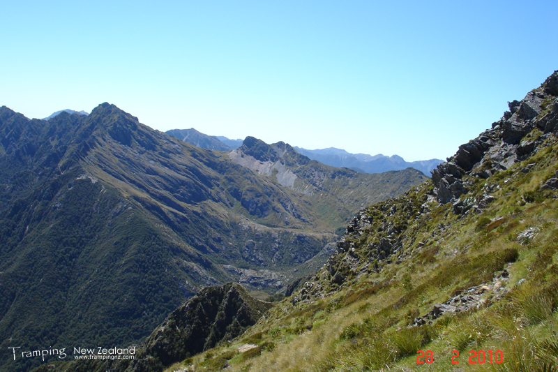
Today the weather turned on us, so no stunning view to wake up to. There was low level cloud and the temperature was cold. So we all got dressed up into warm clothes and wet weather gear (I had 4 layers on).
Once we had breakfast, collected extra water (as there was no known water source for the next day), I ended up having to put some gloves on. This is another day that started with a straight uphill, again I was glad of this but as we got higher in altitude the wind increased, which made it difficult.
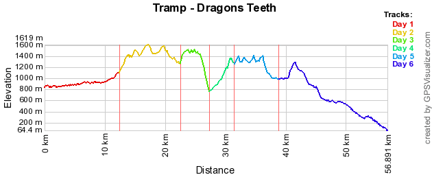
We headed towards our planned stop for the night on top of Anatoki Peak which is on the way to Dragons Teeth. As we headed along the ridge (through heads of valleys) we were getting higher in altitude.
Then we started climbing towards 1600m to start the high traverse of the Dragons Teeth. This starting involving climbing up rock faces. As we were going up the weather was getting worse, it was closing in on us. We got to a point where we got stuck on top of a peak. We scouted out were to next and it was not looking good. There was lots of shear rock faces and a huge valley to cross. This presented us a problem.
After a while of scouting it was decided as a group that this was becoming dangerous and we noticed that the information researched for the trip did not give the full picture, we were most likely needing rock climbing gear like ropes, etc. At this time we were thinking of options including setting off our personal locator beacon and changing our intended route. So in the end we decided to turn back, as we did this the weather came in more. We managed to find some shelter under a rock ledge to have lunch.
Once finished lunch, we retraced our route back to Drunken Sailors, where we then bush bashed heading to point 744 on the topo map. The bush bashing involved going downhill, and met some cliff rock faces and we had to go round these. We finally found a small stream were we could follow down to Anatoki River (the low route). The small stream had some waterfalls, were we had to navigate down them, which presented some challenges. You also notice that you have to check each of your footing, hands and trees (as some were not very strong).
Will was climbing down one of the waterfalls which four of us managed to descend and one of the trees that was being used gave way which meant the will fell down backwards onto his pack. Lucky there was a rock ledge and a few trees that saved him falling further than a couple of metres. At another waterfall we all had to pretend to be monkeys to climb down a tree, apparently I was the best doing this move.
Finally we got down to the river and to our amazement we found a campsite on the other side of the river, which we could not believe our eyes. This looked like a frequently used campsite by hunters due to the setup of the camp fire (a spit). We setup camp here for the night as it was about 6.30pm, so the light would be fading very soon. So we cooked up dinner and then straight to bed.
Day 4 (Tuesday):
Today it looks like that the weather wants to improve. You could see the clouds hanging around the tops of the mountains. We had breakfast and packed up. Basically today we will be heading up river and over the saddle to Adalide Tarn.
We found some cairns marking the way heading up the river, so this was promising, i.e. we found the low route. We continued along side the river, at some points it involved going inland a little to get round some big rock features.
We finally lost the cairns and there was a clearing uphill and it kind of looked like a route, so we headed straight up. Not knowing that this clearing was from a slip which appears to have happened a long time ago. So we kept heading straight up, which was very steep. Then we got to a point where we had to double check our positing with a compass (due to lack of GPS signal) because we hit a cliff face. We then continued towards the right, as this is the direction we wanted to head, then another cliff face. Unfortunately no where to go and we were already hanging in the trees like monkeys. The only way we could go was straight up.
Going straight up took a long time as each person climbed up vertically, due to this we were heading up into the weather above when then caused us to start getting hythothermia. Still climbing for a long time as only could move one person at a time due to the risks associated (one wrong move and could have been a goner).
Finally we reached near the top of the saddle and guess what, we found a cairn. We decided due to our hythothermia conditions, we setup a tent (it was raining and windy) to provide some shelter. We got a cooker out to boil up a hot drink where we all shared out of a cup of tea, which we all had (this is the first time I had drunk tea). We ate some snacks to boost our energy levels.
Once we all had warmed up we found the next cairn to lead us to Adelide Tarn over the saddle. Climbed up and over the saddle and saw our destination, which was down hill out of the weather. When we got to the hut, we found it occupied with trampers who were waiting out the weather, so this meant that we had to tent (which we planned to anyhow).
We pitched the tent and then cooked up dinner in the hut. As there were very little tent space, for the tent we used earlier in the day had to be dried out. Once this was done it was pitched uphill of the hut. We all changed clothes to warm up and went to bed.
Day 5 (Wednesday):
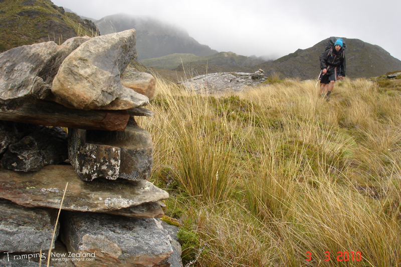
Today we are back on our planned route and heading to Boulder Lake. Again it was a day where it started with uphill heading towards the Needles Eye (a saddle). The weather appears that it is trying to clear today, but unfortunately when we got to the saddle, there was not much of a view with the exception of cloud (so no nice view of Dragons Teeth). Then it was down hill over a rocky outcrop to go along the ridge.
We went along the ridge which quite a bit of it is in bush, which eventually ended up onto very shear rock faces on each side. Traversing the ridge took a while heading towards the Green Saddle. At this point we knew it was soon down hill to Boulder Lake Hut.
Going along a ridge following Cairns | Photo Credit: Alistair
As we headed down the valley we encountered tussock which was taller than most of us in the group, which meant that we lost each other and the way very easily. However we kept going in the direction towards the hut (as this could be seen in the distance). Crossed a couple of small rivers and then we reached the hut.
Boulder Lake Hut sleeps 10 people, so we will be staying in tonight. We played cards for the rest of the afternoon, collected water and cooked some dinner. The weather had cleared up and you could feel the warm sun, but the wind was still cool. Then we went to bed.
Day 6 (Thursday):
The final day, the sun is up and not a cloud in the sky. We had breakfast, packed up and headed off before the heat of the sun started. We followed the lake edge about half way round before heading uphill again. We are headed towards Brown Cow saddle which involved going along a couple of rock faces.
Boulder Lake looking towards Dragons Teeth | Photo Credit: Chris Foster
We reached Brown Cow saddle and rang Peter the transport operator (mobile phone coverage) to notify our status and eta to the road-end at James Road. You could see the farm land and fairwell spit. Headed downhill along the top of the ridges before descending into bush. The bush indicated that we were loosing altitude and coming out of the alpine area.
Kept following the ridges and the bush down. Had a quick lunch and continued on. On the way down it looked like there were quite a lot of rock crevasses which we had to jump over the gaps, you could not see the bottom. Finally hit the 4wd track downhill which took us out to farm land were we were being picked up. We reached the road-end at 3.30pm and the shuttle was waiting for us.
It was a 2 ½ hour drive back to Nelson and we stayed at Honey Suckle Backpackers. We had a few issues were we thought that we were booked into another backpackers, but this was sorted out.
We went out for dinner to a fish & chip shop and next door was a pub, they allowed to have your takeaways delivered to the pub. This allowed us to enjoy our meal with a cold drink and to reflect on our last 6 days tramping. After dinner walked back to our accomodation and went to bed.
Day 7 (Friday):
An early morning start to catch our 6.30am Air New Zealand Flight 8144 to Wellington. We were outside waiting for an airport shuttle driver, no where to be seen. We rang them four times and eventually a Super Shuttle turned up at 6.15am, we advised the driver that he had to floor it. We eventually arrived at the airport 10 minutes later and ran to the counter. Even though we were well after the check-in time they managed to let us on, the packs were quickly offloaded and boarding passes printed. We had to run to the plane, which we managed to successfully delay for 5 minutes, while we and our packs were loaded on. A few minutes later the plane took off.
At 7.10am the plane landed in Wellington. We had a couple of hours to spare before our connecting flight to Auckland. So we found a table in the food court area which overlooks the runway and brought some hot cooked breakfast. Once eaten, we played cards to pass some time. Then we walked round the airport prior to boarding Air New Zealand Flight 418 to Auckland at 10.00am. Had a nice flight where the views over the country were clear as. We finally landed in Auckland 11.00am, collected our packs and headed home.
Maps
- NZTopo50: BP24 - Takaka
- NZTopo50: BP23 - Gouland Downs
- NZTopo50: BN23 - Paturau River
- NZTopo50: BN24 - Collingwood
Further Information
- Department of Conservation - Douglas Range Route
- Potton & Burton Publishing - Classic Tramping in New Zealand


