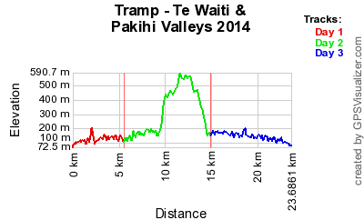
Te Waiti & Pakihi Valleys
Urutawa Conservation Area
31 May - 2 June 2014 (Queens Birthday Weekend)
For Queens Birthday weekend we headed down to Opotiki where none of us had been tramping before. I was joined by Vanessa, Chris S, Chris R & Tim H.
| Day 1 | Travel to Opotiki Te Waiti Stream Road-End (Bushaven Carpark) - Te Waiti Hut Te Waiti Hut Walk | 2 Hours 5.5km |
| Day 2 | Te Waiti Hut – Pakihi Hut | 8 Hours 9.5km |
| Day 3 | Pakihi Hut – Pakihi Road-End Pakihi Track Travel back to Auckland | 3 Hours 8.5km |
 (https://www.trampingnz.com/images/maps/te_waiti_pakihi_valleys_2014.png)
We left Auckland just after 6.30am to head down to Opotiki. Stopped in Huntly for breakfast, continuing onto Hamilton to pickup Tim, then onto Cambridge to get last minute food supplies and Rotorua for those that required hut tickets. So it was a relaxing drive down since we made quite a few stops.
Once we reached to Opotiki we had some lunch at a lunch bar before heading to Te Waiti Road-end (Bushaven). At about 2.00pm we put on our packs and set our course for Te Waiti Hut which is about 2 hours away.
For most of the time we were following the river on the benched track, which was quite easy. About 650m from the hut we had to cross Te Waiti Stream to get to the correct side where the hut was. It had a quite bit of water flowing and it had a deep pool close by.
Once arrived, we went scavenging for firewood for the fire. We managed to find quite a few dead trees down the hill by the stream. We cooked dinner and enjoyed the warm fire and played some card games.
Today is our longest day, so we got up and had breakfast of porriage then packed our packs ready to go at 8am.
From the hut we headed down to the stream to cross to the other side and follow the benched track following Wahaatua Stream. Along the track there is some storm damage and erosion. In some places required to do a slight detour or bush bashing.
Unfortunately at some point late in the morning I slid/fell off the track and down the cliff face a couple of metres. Lucky there were trees that stopped me going further. As it happened so quickly it was difficult to work out what had happened. Due to this my hand was now sore and had quite a bit of bruising and swelling going on. Determined that since I could still move my fingers that I had not broken anything, so we carried on.
We eventually came back down to the stream at Stag Flat where we had a break and I put my hand into the freezing water to relieve the pain and swelling. We then crossed the stream and headed uphill to follow along a ridge, at this point we were navigating by GPS as the track did not really exist, however there were some route markers that we were following. Eventually we made it onto the marked track according to the map, but still of the same track standard of following the route markers. This also presented a bit of a challenging climb due to the uneven ground and trees. We stopped for lunch near point 605.
After lunch we continued along the ridge. From time to time you would see some possum traps and some of them actually contained possums. Some of the possums in the traps were alive and some had died. It looks like that this area is hunted quite a bit for possums which looks pretty successful.
Finally we come down off the ridge into Pakihi River where we passed some landslips. The weather started to turn a little with some rain. We crossed the river to get to the same side as the hut and climbed uphill to reach Pakihi Hut.
Once arrived, found some firewood and got the fire and dinner cooking started. My hand was still causing me some discomfort but bearable by not moving it much. I probably should have tape splint my hand by this point but did not think it was that bad at the time.
Had a nice dinner and then we relaxed on the bunks by using them as couches. We played eye-spy game which there were some tricky challenging objects. This hut also has a cupboard which had quite a few useful supplies.
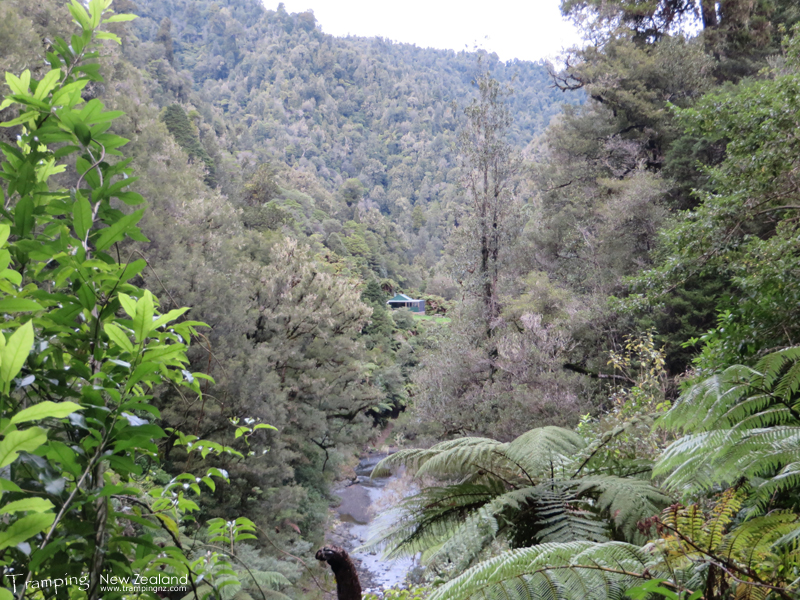 (https://www.trampingnz.com/images/07_east_coast/tewaiti14_pakihi_hut_large.jpg)
Pakihi Hut | Photo Credit: Chris Foster
An easy track today as it is built to a standard that mountain bike users use it. Basically following the Pakihi River all the way down to the road-end. We got up and left at 8am as we had arranged transport picking us up at 11am. We stopped a few times along the way for breaks and had 1st lunch when we got to the road-end. We got picked up and transported back to the car we had parked at Bushaven.
On the way home we stopped for hot pools outside of Rotorua, had 2nd lunch at a café in Rotorua and then Cambridge for Dinner at a takeaways. Finally got back to Auckland about 8pm.
The next day I went my local ShoreCare A&E and had x-rays done of my hand and it was determined that I had fractured my 5th Metacarpal bone. So got put into a cast initially in order for the bone to heal then into a removable splint. So the recovery for whole recovery will take about 10+ weeks. However on a positive note that the orthopaedic specialist and hand therapist/rehab believe I will be all good for my next upcoming tramp. Once thing I had learned is that I should have treated my injury with more seriousness/care by applying better first aid.
View Larger Map (https://www.topomap.co.nz/NZTopoMap?v=2&kml=https%3A%2F%2Fwww.trampingnz.com%2Ffiles%2Fmaps%2Fkml_07_te_waiti_pakihi_valleys_2014.kml)